A Magnitude 6.7 Earthquake Shakes Peru's Southern Andes, Rattling Ayacucho, Ica and Arequipa but Sparing Lives
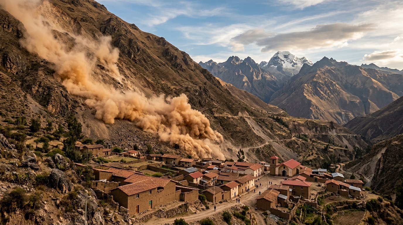
The quake struck 38km northwest of Upahuacho at a depth of 67km, the USGS said, triggering landslides but no immediate reports of deaths or injuries.
Commentary & Analysis ·
Verified key facts
- A magnitude 6.7 earthquake struck Peru's southern Andes at about 1pm local time (18:00 GMT) on Thursday, according to the US Geological Survey, as reported by ABC News
- The epicentre was 38 kilometres (24 miles) northwest of Upahuacho, in the Parinacochas province of the Ayacucho region, at a depth of 66.7 kilometres, the USGS said
- Peru's Geophysical Institute initially reported a magnitude of 7.2 before measurements were revised downward
- The quake was felt across several regions of southern Peru, including Ica and Arequipa, and triggered landslides on mountainsides near the epicentre
- There were no immediate reports of deaths, injuries or major structural damage, and no tsunami warning was issued
- Municipal and regional teams were surveying rural communities, mountain roads and vulnerable homes in Ayacucho before declaring a final toll
A deep, powerful jolt beneath the Andes
A magnitude 6.7 earthquake shook the southern Andes of Peru on Thursday afternoon, sending residents into the streets across a wide swathe of the country's south but causing no immediately reported deaths or injuries. According to the US Geological Survey, cited by ABC News, the quake struck at about 1pm local time, 18:00 GMT.
The epicentre was located 38 kilometres — about 24 miles — northwest of the town of Upahuacho, in the Parinacochas province of the Ayacucho region, a rugged, sparsely populated stretch of high Andean terrain. Crucially, the USGS measured the quake's depth at 66.7 kilometres, deep enough to blunt much of its destructive power at the surface.
First reported at 7.2, then revised down
In the first minutes after the shaking stopped, Peru's Geophysical Institute reported a preliminary magnitude of 7.2 — a figure that, had it held, would have placed the event among the more powerful quakes to strike the country in recent years. Subsequent analysis revised the magnitude downward, and the USGS settled on 6.7.
Such early revisions are routine in seismology, as automated systems produce rapid estimates from a limited number of stations before analysts refine the picture with fuller data. The difference matters: earthquake energy scales steeply with magnitude, and a 7.2 releases roughly five times the energy of a 6.7.
Felt from Ica to Arequipa
The tremor was felt across several regions of southern Peru, including the coastal region of Ica and the city of Arequipa, Peru's second largest, hundreds of kilometres from the epicentre. Reports gathered by AOL described residents pausing in the streets and looking up at dust and debris tumbling down nearby mountainsides.
Landslides were reported in the steep terrain around the epicentre — a familiar hazard in the Andes, where even moderate shaking can loosen rock faces above roads and villages. In a region where many communities are reached by single mountain roads, slides can isolate settlements long after the shaking itself has passed.
Why the damage appears limited
Two factors appear to have spared Peru a far worse afternoon. The first is depth: at nearly 67 kilometres below the surface, the rupture was an intermediate-depth event, and the seismic energy that reached towns above had already spread and weakened considerably compared with a shallow crustal quake of the same magnitude.
The second is geography. Parinacochas province is one of the more remote corners of Ayacucho, with scattered agricultural communities rather than dense urban centres. GV Wire reported no immediate reports of damage in the hours after the quake, and no tsunami warning was issued, as the epicentre lay inland beneath the mountains rather than offshore.
A country built on a subduction zone
Peru sits on one of the most seismically active margins on Earth, where the Nazca oceanic plate dives beneath the South American continent. That subduction zone has produced some of the largest earthquakes ever recorded on the continent, and intermediate-depth events beneath the Andes — like Thursday's — are a regular product of the descending slab.
The country's building stock reflects a long negotiation with that reality. Modern construction in Lima and the major cities is engineered to seismic codes, but adobe and unreinforced masonry remain common in rural highland communities, which is why authorities do not declare an all-clear until inspectors have physically reached outlying villages.
The official response in the first hours
Local officials moved quickly to reassure the public. Reports relayed by El-Balad quoted regional representatives saying no damage had been recorded in the immediate aftermath. Municipal and regional teams continued to survey Parinacochas and nearby towns through the afternoon, checking rural communities, mountain roads and the kind of older, vulnerable homes that fail first in Andean earthquakes.
The official assessment remained open on Thursday evening, pending those inspections. Peru's civil defence practice after a significant quake is deliberately cautious: initial 'no damage' reports from provincial capitals are treated as provisional until the remotest districts have been contacted, a lesson learned from past events where isolated villages took days to report losses.
Inspections continue across Parinacochas
For now, the magnitude 6.7 event will be recorded as a powerful but merciful earthquake — strong enough to be felt across three regions and to send landslides down Andean slopes, deep enough and remote enough to leave the population shaken but apparently unharmed. The USGS data places it firmly within the pattern of intermediate-depth seismicity that defines the region.
Attention over the coming days will focus on the inspection teams working through Parinacochas province and on any aftershock sequence. Aftershocks following an intermediate-depth mainshock tend to be fewer and less damaging than those after shallow quakes, but authorities in Ayacucho have urged residents to remain alert and to check homes for structural cracks before reoccupying them.
Sources
- ABC News - Magnitude 6.7 earthquake shakes Peru's southern Andes, USGS says
- US Geological Survey - M6.7 event data, southern Peru
- AOL - Peru struck by 6.7-mag earthquake felt in Ayacucho and Ica, causing landslides
- GV Wire - Magnitude 6.7 Earthquake Strikes Peru
- El-Balad - Luis Vasquez says no damage after 6.7 Earthquake In Peru
You may also like to read

Body of Missing Teenage Hiker Lily Hooper Found in the NSW Southern Highlands, After the Premier Wrongly Said She Was Alive
The 18-year-old was found after an eight-day search of Nattai National Park involving Defence personnel and hundreds of SES volunteers.
North Korea Fires a Barrage of Ballistic Missiles Hours After Kim Yo-jong Dismisses Trump's Offer to Meet
Pyongyang launched more than ten short-range ballistic missiles into the East Sea as Kim Jong-un's sister said she was unaware of talks with Washington.
SLB and Hunt Oil Sign Venezuela's First US Production Deals of the Post-Maduro Era
Texas firms signed the first contracts with PDVSA since Maduro's capture, as Caracas courts Houston with fields it says are waiting to be discovered.
A Cessna Pilot Is Killed in a Midair Collision With a Pennsylvania State Police Helicopter at Carlisle Airport
A small plane struck a state police Bell 407 during a training flight in central Pennsylvania, killing the plane's pilot and injuring two troopers.